The King Solomon Mine
(Lode )
(20.66 acres)
Lake County, Colorado
$30,000
Now Available!
(Lode )
(20.66 acres)
Lake County, Colorado
$30,000
Now Available!
•Commodities: Gold and Silver
• Claim designation: unpatented-Lode
• Size: 20.66 acres
Financing is available with $2100.00 down and monthly payments of $255.00
• Claim designation: unpatented-Lode
• Size: 20.66 acres
Financing is available with $2100.00 down and monthly payments of $255.00
The King Solomon Mine is a documented mineral property located in the historic Granite mining district of Central Colorado.
Featuring multiple underground portals to over twelve hundred feet in stock workings, exceptional ore grades, and a secluded Creekside location.
Granite is a small mountainside town located on the Arkansas River midway between Leadville to the north and Buena Vista to the south.
The town has a rich history from its days during the Pike's Peak Gold Rush when it began as a mining camp and quickly boomed into a city of 3,000 holding the county seat. Early prospectors, such as Horace Tabor, were attracted to the area.
The King Solomon features development into a rich Gold-bearing quartz vein of the northwest slope, and sample analyses indicate high values of Gold in select samples on the mine face and spill dump.
With original work most likely begun in the late 1890s, the production peaked in the 1930s before WW2 under the ownership of the Granite Tunnel Mining company.
Interest in the mines was revived briefly in the 1960s through the early 1980s by larger companies such as Anaconda and Exxon, eventually, the fuel crises of the 1980s brought all work to a halt. After over thirty years of inactivity, the King Solomon mine has been revived to continue production.
- Primary workings consist of the easily accessible lower haulage adit resting on the southern edge of the property with connecting stock works to inclined shafts on the northern edge.
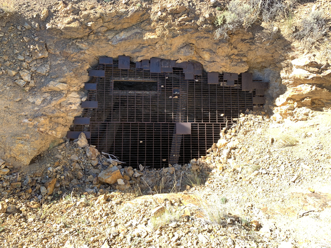
Two primary inclined shafts are wide industrial-style cuts (12' by 9' openings for the old tram and manway system) with steel bat gates on the access points.
Shafts were driven at a decline on the primary deposit about 600 feet north of the haulage adits. Estimated at 225'-250' in-depth, the shafts were driven on the lateral vein strike trending NE.
The third and highest elevation inclined shaft is partially caved on the portal due to erosion, it is thought to have been one of the original discoveries given the older style wooden headframe that has also collapsed into the access drift of the third shaft.
- Primary deposit is comprised of a heavily mineralized quartz vein, trending northeast with heavy sulfide zones.
- Estimated mineral values of the vein material are ranging between: 1.75-to-2.3 opt Au (Gold) and 10.5-to-34 opt Ag (Silver).
The combined spill holds excellent potential for milling at a profit, as the higher-grade material was trucked out during production to an offsite mill location.
Pictured grab samples from the upper shaft spill display higher-grade material specimens.
Accessible by any 4x4 vehicle from the northern route and by ATV only via the southern route outside of Granite.
Level camping and staging areas are located near the Creekside Valley.
This historic producer holds prime potential for precious minerals in one of the richest mining districts of central Colorado.
Available to the beginning enthusiast up to the established mining company.


